Mahaanui Iwi Management Plan

Our natural environment – whenua, waters, coasts, oceans flora and fauna – and how we engage with it, is crucial to our identity, our sense of unique culture and our ongoing ability to keep our tikanga and mahinga kai practices alive.

It includes our  commemoration of the places our tūpuna moved through in Te Waipounamu, and the particular mahinga kai resources and practices we used to maintain our ahi kā anchoring our hakapapa to the landscape. Wherever we are in the world, these things give us our tūrangawaewae. They form our home and give us a place to return and mihi to and provide us with what we need to be sustained as Ngāi Tahu.”

1.1 He Kupu Whakataki | Introduction

This Iwi Management Plan (IMP) is an expression of kaitiakitanga and rangatiratanga. It is a manawhenua planning document reflecting the collective efforts of six Papatipu Rūnanga that represent the hapū who hold manawhenua rights over lands and waters within the takiwā from the Hurunui River to the Hakatere River and inland to Kā Tiritiri o Te Moana:

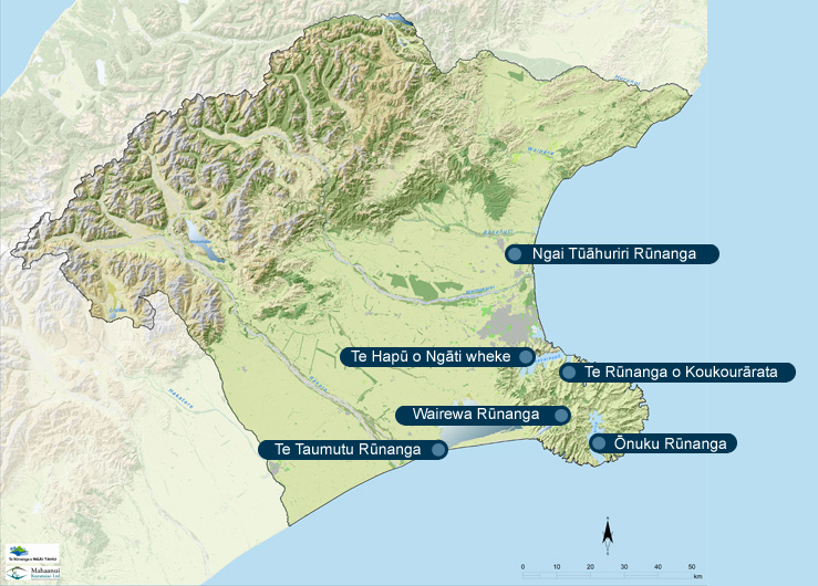
The plan provides a values-based, plain language policy framework for the protection and enhancement of Ngāi Tahu values, and for achieving outcomes that provide for the relationship of Ngāi Tahu with natural resources across Ngā Pākihi Whakatekateka o Waitaha and Te Pātaka o Rākaihautū (see Map 1).

The plan has the mandate of the six Papatipu Rūnanga, and is endorsed by Te Rūnanga o Ngāi Tahu, as the iwi authority. As such, it is applicable to policy and planning processes under the Resource Management Act (RMA) 1991.

By naming our plan “Mahaanui” we are acknowledging the connection between our hapū, and the shared commitment to protecting and restoring the health of the land, water, mahinga kai and biodiversity of the takiwā. We take the name Mahaanui from Te Tai o Mahaanui, the tide that connects the six marae. From the Waimakariri to the Hakatere, the tide of Mahaanui laps against the whenua embracing the six hapū.

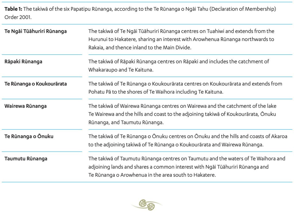
Table 1 sets out the takiwā boundaries of each Papatipu Rūnanga according to the Te Rūnanga o Ngāi Tahu (Declaration of Membership Act) Order 2001. Part 3 of the IMP (Manawhenua) provides information on the history and takiwā of the six Papatipu Rūnanga, and includes a map showing the location of marae.

Map 1: The area covered by this IMP

Note:

In defining the boundaries of this IMP, Ngā Rūnanga recognise that the Rakaia and Hakatere rivers are areas of shared interest with Te Rūnanga o Arowhenua, and the Hurunui River is an area of shared interest with Te Rūnanga o Kaikōura.

Te Rūnanga o Arowhenua

The takiwā of Te Rūnanga o Arowhenua centres on Arowhenua and extends from Rakaia to Waitaki, sharing interests with Ngāi Tūāhuriri ki Kaiapoi between Hakatere and Rakaia, and thence inland to Aoraki and the Main Divide.

Te Rūnanga o Kaikōura

The takiwā of Te Rūnanga o Kaikōura centres on Takahanga and extends from Te Parinui o Whiti to the Hurunui River and inland to the Main Divide.

1.2 Te Take O Te Mahere | Purpose of the plan

This IMP provides a statement of Ngāi Tahu objectives, issues and policies for natural resource and environmental management in the takiwā as per Map. The plan is a tool for tāngata whenua to:

  • Express kaitiakitanga, by effectively and roactively applying Ngāi Tahu values and policies to natural resource and environmental  management; and
  • Protect taonga and the relationship of tāngata whenua to these, by ensuring that the management of land and water resources achieves meaningful cultural and environmental outcomes.

While the plan is first and foremost a planning document to assist Papatipu Rūnanga to participate effectively in natural resource and environmental management in the takiwā, a fundamental objective of the plan is to enable external agencies to understand issues of  ignificance to tāngata whenua, and how those issues can be resolved in a manner consistent with cultural values and  interests.

The plan provides a tool for local authorities, other agencies and the wider community to:

  • Understand what is important to tāngata whenua and why;
  • Meet statutory obligations under the NTCSA 1998, RMA
    1991 and other legislation, including recognising and providing for the  relationship of Ngāi Tahu to ancestral land, water, wāhi tapu and wāhi taonga as a matter of national importance;
  • Determine the nature and extent of consultation that may be required regarding particular activities or places of importance; and
  • Afford appropriate weight to Ngāi Tahu values in decision making processes.

"This plan is for our children."

"I am overjoyed to see that we are going to put in place a tool to help us get back what has been degraded. We have lost a lot here. I want to see a plan in place that helps recover what has been lost."

“We can grow, develop, and make ourselves stronger because we have the basics and bottom lines set out in a plan. We can use the plan to support us, and guide others.”

1.3 Ngā Hononga Ki Ētahi Atu Mahere | Relationship with other plans

The Mahaanui IMP 2013 is part of a larger network of regional and territorial planning documents. The plan sits alongside the regional council’s Canterbury Regional Policy Statement (RPS), the Land and Water Regional Plan (LWRP), district and city plans prepared by territorial authorities, conservation management plans, strategies and other plans prepared by Te Papa Atawhai/Department of Conservation, and other planning documents, as the voice of Ngāi Tahu in Ngā Pākihi Whakatekateka o Waitaha and Te Pātaka o Rākaihautū.

The IMP also sits alongside existing tribal policy and Iwi Management Plans in the takiwā, including Te Poha o Tohu Raumati: Te  Rūnangao Kaikōura Environmental Management Plan 2005; the Te Waihora Joint Management Plan 2005, the Te Rūnanga o Ngāi Tahu Freshwater Policy Statement 1999, and the Te Rūnanga o Ngāi Tahu Hazardous Substances and New Organisms Policy Statement 2008. It joins the increasing number of IMP developed by Ngāi Tahu whānui in other takiwā, including Te Tangi a Tauira: Ngāi Tahu ki Murihiku Natural Resource and Environmental Management Plan 2008 and the Kai Tahu ki Otago Natural Resource Management Plan 2005.

The IMP follows in the footsteps of two earlier iwi management plans, Te Whakatau Kaupapa, the Ngāi Tahu Resource Management Strategy for the Canterbury Region (1990) and the Te Taumutu Rūnanga Natural Resources Management Plan 2003. These plans are taonga in their own right and remain valuable sources of  information on values and history. However for  planning purposes, the Mahaanui IMP 2013 is the principal manawhenua planning document for the six Papatipu Rūnanga as identified in this IMP.

"Our expectation is that this IMP will sit alongside the Regional Policy Statement and regional, district and city plans as a Ngāi Tahu statement on how to achieve the sustainable management of natural resources in Canterbury."

1.4 Te Whakatipu I Te Mahere | How the plan was developed

The Mahaanui IMP was developed over a three year period from 2009 to 2012. The process of preparing the IMP was in many ways as important as the outcome. Developing the plan gave Ngā Rūnanga a forum to discuss shared values and issues, and the policies needed to address issues of resource management significance in the takiwā. 

The following methods were used to develop the IMP:

  • An IMP Working Group consisting of 1–2 representatives from each of the six Papatipu Rūnanga was responsible for overseeing and guiding the development of the plan.
  • A scoping workshop with iwi and hapū practitioners who had prepared or worked with IMP provided an opportunity to discuss the range of options available for IMP development, and identify what would work best for the development of a collective IMP.
  • A review of existing information provided a solid basis for the issues and policies. The review included existing iwi management plans, Cultural Impact assessments (CIA), Cultural Value Reports, Cultural Health Assessments/State of the Takiwā studies, Cultural Mapping Reports, submissions, hearings evidence, technical reports, historical documents and other written information from both Papatipu Rūnanga and Te Rūnanga o Ngāi Tahu. A focus of the IMP development process was the ‘bringing together of information into one place’.
  • Marae based hui were used to identify and discuss issues of significance at both the regional and local (catchment) scale. The information from these hui provided the overall direction and focus for the issues and policies in the IMP.
  • Interviews and discussions with tangata whenua with knowledge and experience of particular places, resources or activities of cultural importance (e.g. mahinga kai) provided the detail required to flesh out issues and policies in specific sections.
  • Hīkoi were used to further identify and discuss localised issues of significance, and to follow up on issues raised at hui and interviews.
  • Council workshops with regional, city and district council staff provided an opportunity for council staff to discuss their experiences with existing IMP, and how the Mahaanui IMP could best assist them to recognise and provide for tāngata whenua values in natural resource management.
  • Collaboration, support and advice from Te Rūnanga o Ngāi Tahu (Toitū Te Whenua), the Historic Places Trust and other agencies and people assisted with the formulation of good policy to address specific issues.

1.5 Me Pēhea Te Whakamahi I Te Mahere Nei | How to use this plan

The Mahaanui IMP is divided into 6 parts:

Part 1 identifies the purpose and structure of the plan, and explains how to use the document.

Part 2 identifies the expectations and opportunities associated with implementing the plan.

Part 3 introduces plan users to the six Papatipu Rūnanga that prepared this IMP, and includes a description of takiwā boundaries.

Part 4 provides an overview of the cultural framework for Ngāi Tahu approaches to resource management, and the legal framework for tangata whenua participation in resource management.

Part 5 outlines regional objectives, issues and policies. Part 5 is divided into 8 policy sections (Sections 5.1 to 5.8) addressing Kaitiakitanga, Wai Māori (freshwater) and Ngā Tūtohu Whenua (cultural landscapes), and the domains of Ranginui (sky), Papatūānuku (land), Tāne Mahuta (mahinga kai and biodiversity), Tangaroa (oceans) and Tāwhirimātea (climate change). These policies apply to the whole of the takiwā covered by the Plan except where replaced by a locally specific policy in the catchment sections in Part 6.

Part 6 is divided into 12 catchment or distinctive geographical area sections (Sections 6.1 to 6.12). Policies in these sections sit alongside the regional policies in Part 5, and address issues of local significance in the catchment or geographical area.

Using the plan is based on a number of key points:

  • While the plan is a collective statement of values and policy, it does not replace to need to engage with the appropriate Papatipu Rūnanga for resource management issues in particular takiwā. Section 5.1 (Issue K2 – Recognition of Manawhenua) sets out the policy framework for engagement with the appropriate Papatipu Rūnanga.
  • Each section in Part 5 and Part 6 begins with a list of Ngā Paetae/Objectives (what Papatipu Rūnanga want to achieve), followed by Ngā Take/Issues of Significance and the Ngā Kaupapa/Policies to resolve those issues. He Kupu  hakamāhukihuki/Explanations  follow each issue and corresponding policies.
  • It is important that Parts 5 and 6 are used together. Issues not covered in Part 6 of the plan will by default be addressed under regional policy in Part 5.
  • Cross referencing is used to avoid duplication of material throughout the plan, and to facilitate working between Part 5 (Regional Policy) and Part 6 (Catchment Policy).
  • Information resources are listed in various sections of the Plan. These references can be used to obtain further information on a specific issue or policy area.
  • A glossary is provided at the end of the plan to assist plan users with translations, and with definitions of Māori terms and concepts.

Policy conventions:

The policies in this plan are written in a style that reflects what Papatipu Rūnanga support, require, encourage, or will do with regard to resolving issues of significance in a manner consistent with the protection and enhancement of Ngāi Tahu values, and achieve the objectives set out in the plan. Policies include process, method, assessment or objective related information. The following are the most common policy conventions used in the Plan:

To require: Something that must be done to resolve an issue and protect Ngāi Tahu values, and achieve the objectives of this plan.

To support: To give strength and recognition to an action, activity or party that recognises and protects Ngāi Tahu values.

To protect: To make certain that an action or activity assists in safeguarding Ngāi Tahu values, avoiding effects and meeting the objectives of this plan.

To encourage: To provide support for, or give confidence to, those parties/actions/activities that are consistent with the objectives in this IMP and can enhance Ngāi Tahu values.

To ensure: To make certain that an action or method recognises Ngāi Tahu values and achieves specific cultural outcomes as set out in this plan.

To oppose: An activity or action must not occur in order to achieve the objectives of this plan and to protect Ngāi Tahu values.

To assess: Means that Papatipu Rūnanga will consider an activity or action based on a number of considerations concerning the protection of cultural values.


1.6 He Whakatakotoranga Kupu | Terminology

The terms ‘Ngāi Tahu’ and ‘tāngata whenua’ are used interchangeably in this plan to refer to the six Papatipu Rūnanga that represent the hapū who hold manawhenua rights over lands and waters within the takiwā covered by this IMP.

‘Papatipu Rūnanga’ is used to recognise that individual Rūnanga have kaitiaki and manawhenua interests in their respective takiwā.

‘Local authorities’ and ‘local government’ are used to refer to regional and territorial authorities in the takiwā covered by this IMP: the regional council, district councils and city council.

A glossary is included at the end of the IMP to provide plan users with translations and key definitions.

1.7 Ngā Mahere Whenua | Mapping tools

The IMP does not provide a comprehensive inventory or volume of planning maps for significant sites. As described in Section 5.8, Papatipu Rūnanga are currently working with Te Rūnanga o Ngāi Tahu on the Ngāi Tahu Cultural Heritage Mapping Project. Once complete*, the project will provide a reliable and accurate basis of information for Papatipu Rūnanga to create and inform planning maps and inventories.

Wāhi tapu and wāhi taonga issues and policies in the IMP reflect the need to implement appropriate processes and methods to identify, protect and manage cultural landscape values, including wāhi tapu and wāhi taonga.

The IMP provides a schedule of silent file maps, a regional map of New Zealand Archaeological Association (NZAA) sites, and a map showing sites registered with the New Zealand Historic Places Trust Pouhere Taonga (NZHPT).

All maps are prepared by Te Rūnanga o Ngāi Tahu, unless otherwise noted.

* The Ka Huru Manu project is now complete. You may also wish to check Canterbury Maps online. Please note that both of these mapping systems are living documents. As they are constantly being revised, information in them can only be considered to be a guide.