Ngāi Tūāhuriri Rūnanga

Maka ra ki Tawhiti ki ngā
Whenua hou
Ki ngā maunganunui Ki Horomangaraia
Ki Te Tuahiwi o Te Rangiora
Tuahiwi
The name of our marae is Tuahiwi. Tuahiwi takes its name from the ridge that runs from the Kaiapoi township through to Rangiora. That ridge is where the Tuahiwi roadway now runs and our people have traditionally built upon that ridge rather than the lower lying areas that were prone to flooding.
The modern history of Tuahiwi starts in 1848 when the Crown set aside the Kaiapoi Māori Reserve (873) as a ‘kāinga nohoanga’ for our people to live upon. Before the area had been set aside our people had been living in a number of kāinga nearby at Wai-tuere, Mairaki and Tioriori as Kaiapoi Pā had been sanctioned as a ‘wāhi tapu’ – sacred ground.
The first whare was Tū-te-kawa, and was built in 1859. Tū-te-kawa suffered from a serious fire in 1872. Despite the fire our people continued to use the whare through 1879. In 1880 a new whare called Tū-āhu-riri was built as an adjoining whare to Tū-te-kawa. However two months later a storm struck and Tū-āhu-riri was lifted off its foundations. The hall was replaced with a new and larger building. That building retained the name Tū-āhu-riri, and remained as the local meeting house through to the building of a new whare our elders named Maahunui, which was opened in 1922.
Maahunui II
On December 1, 2012, Maahunui II was opened (top photo: Photo credit: Lee Howell / leehowell.com). The new wharenui takes its name from the canoe of our shared ancestor, Māui-tikitiki-a-Te-Raka. ‘Te Waka o Māui’ – The canoe of Māui – is the oldest name for the South Island of New Zealand. Māui is known throughout the Pacific as the great hero figure who discovered fire, slowed the sun in his pathway across the sky and hauled the islands of the Pacific from the ocean floor to the world of light. He is seen as the hero who established our daily customs while challenging the established order.
Kaiapoi Māori Rūnanga to Ngāi Tū-āhu-riri Rūnanga
Under the 1848 Canterbury Purchase the largest block of reserved land set aside for Ngāi Tahu was the Kaiapoi Māori Reserve 873. However, as a result of the land being granted by the Crown, traditional customary rights were uncertain giving rise to a need for title clarity for tribal members and whānau. In response to this need our people decided to establish a tribal council or Rūnanga to determine issues of property and how they would collectively live upon the Reserve. In 1859 the Kaiapoi Rūnanga was established. It was to be the first Rūnanga in New Zealand. The Rūnanga constitution was clear that it was a meeting of land owners decided in common by the people and confirmed under the 1862 Crown Grants Act. Since its establishment the Kaiapoi Māori Rūnanga has often been referred to as the Tuahiwi Rūnanga and latterly as the Ngāi Tūāhuriri Rūnanga as stated in the 1996 Te Rūnanga o Ngāi Tahu Act.
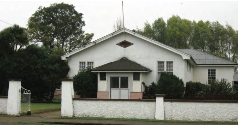
Photo: Photo: Maahunui, also known the Tuahiwi Hall. | Photo credit: Aotearoa People’s Network Kaharoa (2010).
Since its conception the Rūnanga has been designed to represent the land-owners assigned to their Reserves. The authority for Rūnanga is therefore commensurate to the Reserves the Crown assigned to each region. This is important because Rūnanga do not represent hapū boundaries. That is, although the Ngāi Tūāhuriri Rūnanga claims hapū status, its origin is in Kaiapoi Māori Rūnanga which represents the views of the shareholder/land owner. The lands allocated to this Rūnanga start from North Canterbury with the fishing easements of Wamaiaia and runs through to Te Ihutai (Sumner) in Christchurch. Likewise Reserves the Crown set aside for occupation and as compensation were first established at Kaiapoi, run northwards to Oxford and Tawera and end as far south as Rakaia and Hakatere (Ashburton).
Mahinga kai sites claimed by whānau and their Rūnanga before the 1868 Native Land Court essentially defined the Ngāi Tahu Claim to mahinga kai and whānau rights. These claims clearly outline the interest of Rūnanga, with the Kaiapoi Rūnanga claims running from North Canterbury, through to Godley Head, along the Port Hills to Taitapu and heading southwards along Lake Ellesmere (Waihora) to the Rakaia-Ashburton regions where their Reserves were allocated. These rights were never disputed because all whānau from Taumutu through to Rapaki and Kaiapoi understood the custom of their claims and the status of the whānau.
Under the Te Rūnanga o Ngāi Tahu Act 1996, the boundary for the Ngāi Tū-āhu-riri Rūnanga is stated as follows:
The takiwā of Te Ngāi Tuahuriri Rūnanga centres on Tuahiwi and extends from the Hurunui to Hakatere, sharing an interest with Arowhenua Rūnanga northwards to Rakaia, and thence inland to the Main Divide.